
A quick weather update.

Image credit tropical tidbits.
When we look at the 500 mb pattern over North America.We can see the western ridge and the building eastern ridge over the CONUS. This overall pattern is very warm for 2⁄3 of the US. but we do have an upper level low off the West Coast that will bring us big changes in our weather here in the Northeast over the weekend into next week.
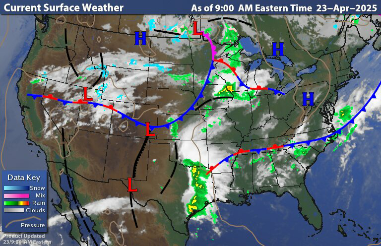
The current surface chart shows high pressure dominating over the Northeast and northern Middle Atlantic. We can see that frontal boundary well to our south As well as a low pressure frontal system over the Upper Midwest and upper Great Lakes. For most of the rest of this week our region is going to be under the influence of this high pressure providing nice and tranquil springtime weather. Today it will be warm with light winds. All the rain we see well to our South is gonna stay well to our south, as that moves east and then head out to sea.
Tomorrow and Friday are gonna be even warmer. The system up over the Great Lakes is going to push north and east tomorrow; but it will be weakening as it slips to our north. Most of our region will stay dry but northern parts of New York state and northern New England could see a few isolated rain showers out of it. That system currently off the West Coast Is going to move into the Plains. Then on friday as high pressure slides east The low pressure will be approaching our region. The frontal system will bring increased clouds , The leading warm front will jump up our temperatures to well above average for this time of year Then as Get into Saturday A prefrontal boundary, will move through Friday night into Saturday bringing some rain and thunderstorms west to east across the region.

On Saturday we will have clearing skies behind the prefrontal boundary How much sun we end up seeing will be a big determining factor and how unstable things get. The cold front will move through Saturday morning Into Saturday evening, bringing widespread rain and thunderstorms. How much sun we see before the cold front moves through will be the determining factor on how big the severe threat will be. As I said yesterday, I think those are the biggest chance of seeing some severe weather Eastern New York State into western New England and down into the northern Middle Atlantic. We have time so we just have to see how everything works out. Saturday out ahead of the cold front is going to be very warm How warm places get will depend on the timing of the frontal passage.
Sunday we'll see the cold front move off the coast as high pressure builds into the region this will provide clearing skies and much cooler temperatures this high pressure is gonna stay with us through Monday keeping us dry. Tuesday the high pressure will start to slip east As a trough approaches From the west. Right now it's looking to me like the planes into the midwest could see quite a bit of severe weather for Monday into Tuesday We'll just have to see how that shakes out. But for here, we will have a chance for a few rain showers on our Tuesday. Out ahead of this trough, a fairly strong southern flow will have Temperatures become quite mild on Tuesday into Wednesday giving the air a summer light feel Then on Wednesday The cold front is going to slide into the region during the afternoon into Wednesday night, bringing more in the way of widespread rain and isolated thunderstorms.
No comments:
Post a Comment
Thank you for taking the time to comment, I will answer as soon as I can.