
Happy Cinco de Mayo day!
In my last post I mentioned how dry the Mid Atlantic and large part of southern and central New England is

The last few weeks have brought frequent rounds of showers into the region. The rain has been easing the abnormally dry and drought conditions across the region. In spite of the rain A large area from Maryland Up through Massachusetts, Southeast New Hampshire into southwest Maine are experiencing moderate to severe drought.
The wet pattern looks to last for another week or so then after that we look to transition to a warmer and dryer pattern during the second half of May.


The weekend was quite wet. The current surface chart and the 500 MB image from tropical tidbits, show the upper level low sitting in the Ohio valley; as well as the upper level low over the southwest United States. Both of these are cut off from the main flow.
Saturday into Sunday The upper level pattern, had low pressure over the southwest; then there's high pressure up in Canada and an area of low pressure over the East. If you draw a line around these features you would get the Greek sign of omega. This is called an omega block. This kind of pattern where the lows become cut off from the northern jet leeds to things becoming stagnant in the upper atmosphere, so we don't see a lot of movement west to east due to everything being stuck. That has certainly been the case for the last few days.

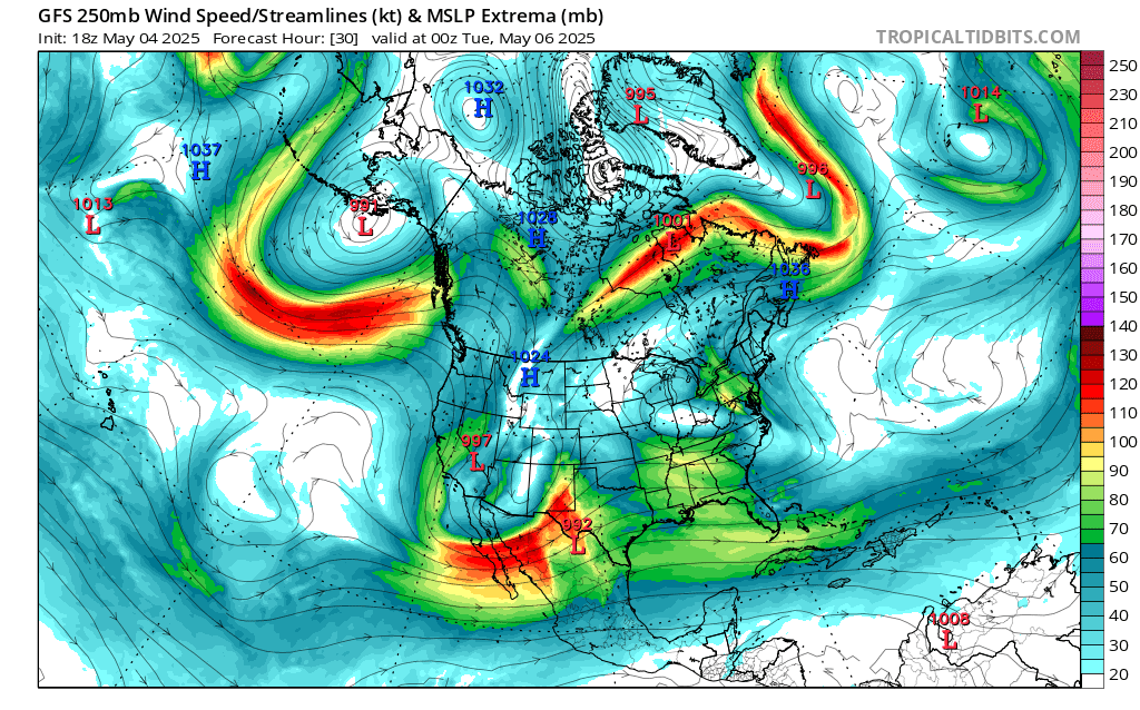
That upper level low over the Southwest is also gonna start to track east. It's going to be moving slow So it'll probably still be having some influence on our weather as we get into the second half of this week.

Today that cut off low in the Ohio Valley is going to ever so slowly start to push east, and slowly weaken. So,we have a lot of clouds and we're still gonna run the risk for scattered showers and some thunderstorms. Some of these thunderstorms could be on the strong to severe side. The Storm Prediction Center (SPC) has a Marginal Risk for severe weather over southwest New York State, a large part of Pennsylvania, Maryland and Delaware. They have a Slight Risk for severe weather over western Pennsylvania into parts of Maryland. The biggest risk will be strong damaging wind gust and hail; the tornado risk is low but as always it's not zero. Out ahead of all of this we do have southern moisture streaming north into parts of the northern mid Atlantic and southern new England
Y'all can see this on the infrared satellite image.

As the day goes on rain and isolated thunderstorms, will become more widespread in these areas and it could rain heavy at times. The rest of the region Over on the rest for a few scattered showers, This morning and to the first part of the afternoon After that Rain and embedded thunderstorms, will be moving north and west encompassing much of the Pennsylvania , New York State Into southern and central New England late afternoon into tonight. The rain will be working into northern New England late tonight and into tomorrow morning.
Tomorrow we will see that upper level low with a cold front continue to approach and move into the region. With this we will see scattered rain showers that will be heavy at times along with embedded thunderstorms. The upper level low Will start to push East Tomorrow night into Wednesday, but there will still be lingering rain showers across the region. Wednesday afternoon Into Thursday We will see clearing skies west to east with dry to mostly dry conditions For Thursday afternoon /evening another cold front will approach the region With the frontal passage we will see scattered rain showers and a few garden variety thunderstorms.
On friday We're going to see an area of low pressure develop Over the Virginia's This will bring rain south to north Into Pennsylvania and the northern Middle Atlantic Friday afternoon. Friday evening into Saturday the upper level low will be moving north and east and starting to exit the region rain and thunderstorms will be encompassing the rest of the region during that time. Saturday as the low continues to push away we will continue to see scattered rain showers and isolated thunderstorms. Skies will gradually clear as time goes on. High pressure will be approaching Saturday night and will be sitting overhead for Sunday For Sunday we should see dry conditions across most of the region, but parts of northern New England could see some scattered range showers, due to closer proximity to that upper level low. Right now, Monday looks to see the high pressure still overhead providing plenty of sunshine and dry conditions.
Thank you for this! Appreciate the detailed explanation.
ReplyDeleteYou're welcome
DeleteAs always. Thank you
ReplyDelete