
Well we made it Thursday Here is a quick Forecast for the next few days The severe threat for parts of our region are increasing as we head towards Saturday.

Today is looking to be a big severe weather outbreak for Wisconsin into Indiana and down into Missouri, then later in the day the severe will stretch into the Ohio valley. The threat is going to include Large to giant hill strong damaging winds and tornadoes some of these tornadoes could be strong.
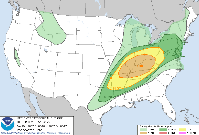
For tomorrow The severe threat will shift a little east and south The southern tier of New York State Pennsylvania Into western Maryland and down into the northern middle Atlantic are at a marginal risk for severe weather. The main threat tomorrow will be damaging winds and hail; right now the tornado threat tomorrow in these areas is low but not zero.
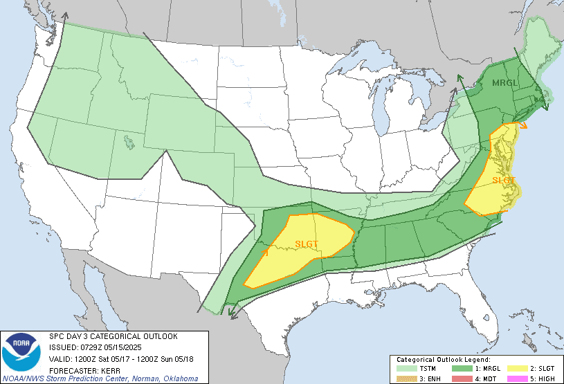
As I talked about yesterday As this system continues to push east there will be a severe threat Into parts of the Northeast and northern Mid Atlantic for Saturday. Right now The storm prediction center (SPC) has a Marginal Risk for severe weather over a large part of New York State into a large part of New England And eastern half of Pennsylvania with a Slight Risk for severe weather over the northern Middle Atlantic, The risk is going to include strong damaging winds hail and isolated tornadoes can also be thrown into the mix.
The severe threat over the next couple of days can be attributed to that upper level low that is moving out of the northwest with its bowling ball trough moving out ahead of it.

Today's surface chart Shows that stationary front with the low pressure and attached warm front starting to move north. This will bring rain showers and some thunderstorms first to the Middle Atlantic. Any breaks in the cloud cover Will help destabilize things enough there is a chance some of the thunderstorms could be on a strong too severe side The SPC has a Slight Risk for severe weather over parts of the northern Middle Atlantic. As all of this moves north. But right now I think the severe risk will be fairly isolated. As the western system approaches and works with that system coming out of the Middle Atlantic; we will have a warm front and a couple cold fronts to deal with. Today a southern flow will send temperatures up as well as humidity levels increasing so it will feel a bit muggy. Away from the med Atlantic the rest of the region will run the risk for scattered rain showers and possibly a few thunderstorms. For tomorrow it will be much of the same with a warm front that will be lifting through making the rain risk and storm risk increasing the further north you are, as all of this tracks north and east.
As I talked about earlier Saturday the cold front that will be swinging through will increase the risk for severe weather. The severe threat will greatly depend on how much clearing we see between the thunderstorms and showers earlier in the day. How much sun we see will determine how widespread the severe weather will be later in the day ahead of the cold front. Sunday will see the system starting to pull away Lingering rain showers and clearing out west to east across the region. Maine will be the last to clear out later Sunday. For next week we look to be much cooler, as high pressure noses in from Canada. Both 1 day and Tuesday Both Monday and Tuesday we'll see the chance for isolated rain showers. Also on Monday and Tuesday we will have another bowling ball of low pressure Starting to move away from the west coast out ahead of this will be more severe weather As we get into the second half of next week The high pressure will be leaving the region As another system with a cold front approaches . Out ahead of the system we will start to see temperatures trying to warm a bit. For Thursday and Friday moderate to heavy rain and isolated thunderstorms will over-spreading the region, along with chances for severe weather increasing.
Some have been saying that my post have been getting a little too long making them harder to read. So I've shortened them down a little bit Please let me know if you like the more detailed forecast or if you like them stripped down more like this one was.
I like them shorter when there isn't much going on. But, when setting up for some possible severe weather, I like the longer ones. Thank you for the time you put in to these. Have a good day!
ReplyDeleteThank you for the feedback
DeleteI agree with Anonymous. Thank you.
ReplyDeleteThanks
Delete