
The end is in sight!
Looking at the current surface chart
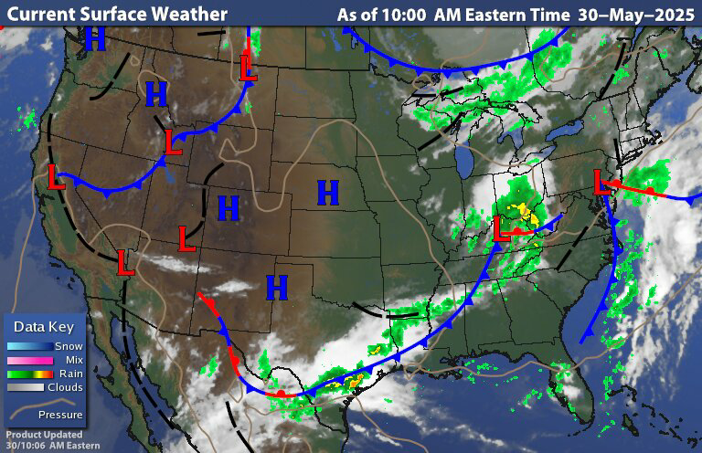
We can see that weak area of low pressure riding the frontal boundary Over southeast Pennsylvania We can also see low pressure over the Ohio Valley. The western low Is going to be the primary weather maker for us over the weekend.This is gonna cause the development of an upper level low Over Virginia That is going to live north and east At the same time we're gonna see a surface load develop That is going to move over or close to New Jersey then track into southern new England.


Satellite shows Most of the region is socked in under clouds with a lot of lifting out over the Ohio Valley associated with that area of low pressure.

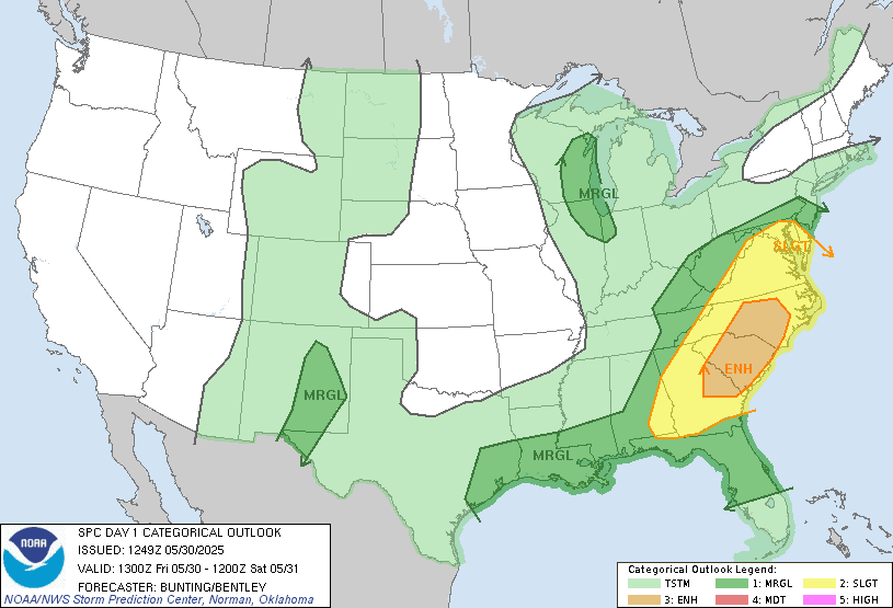
Radar shows most of the region Is dry but we do have isolated rain showers over Long Island and over the Cape. These are associated with weakening area of low pressure. The radar also shows Rain starting to push into southwest Pennsylvania. Most of the region should stay mostly dry today with only a chance for isolated showers here and there.The rain will continue to spread east across southern Pennsylvania today. Then tonight as the surface and upper level lows form. The middle Atlantic region will see widespread showers and thunderstorms develop. Some of these thunderstorms could be strong to severe. The Storm Prediction Center (SPC) has a Slight Risk for severe weather over Maryland and Delaware. With a Marginal Risk over southeast Pennsylvania and southern New Jersey.
Tonight into tomorrow morning, the storm system will be moving north and east Bringing widespread rain showers and some thunderstorms spreading south to north across most of the region. The heaviest rain should fall during the overnight into early Saturday morning. This will be a quick moving system so by the afternoon even Maine should start to see clearing conditions and showers becoming much more scattered. Interior parts of the region should see a general half an inch to an inch and a half of rainfall. With the risk of having heavy rain at times those closer to the lows track could experience some localized flooding. These areas could end up 1 to 3 inches of rain with locally higher amounts possible.


Sunday will be The best day of the weekend With most of us only having a chance for an isolated shower here and there but parts of new England could see a little bit more in the way of rain during the day By Monday into Tuesday high pressure building overhead providing dry and nice weather.

This weekend we're going to have a deep trough over the Northeast and Middle Atlantic region. Then starting next week we're going to start to See the Southeast Ridge become more dominant in our weather pattern This will lead to more in the way of consistent Summer weather as warm humid air pushes north out of the Southeast, Gulf of Mexico and Caribbean. Next midweek we will see yet another upper level low form near the Middle Atlantic. But this one will be much weaker than we've been dealing with. After this, the northern polar jet will push even further north; allowing some of this warmer and more humid air mass to move further north into New York State and central and northern New England by the second week of June. The storm track is also going to shift. With the colder air Cooler and dryer air to the north and warm humid air trying to come north, Our region will be more prone to thunderstorms Some of these will be strong to severe as we move further into June. I still don't see a lot of super hot weather over our region during at least the first half of Summer. Those with the greatest chance of seeing more in the way of coolish temperatures will be northern New York State and northern New England. As they will be closer to that temperature boundary.
"Radar shows most of the region Is dry" ...... except in places like here in Hudson Massachusetts where it has been showery the last 2-3 hours - just an obs, ya' know. We were talking this morning that the last 11 Saturdays has seen rain and tomorrow will be the 12th. An astounding cycle that we have ben in. Thanks for the blog!
ReplyDeleteYes over the last so to three months the region has seen a lot of rain.
DeleteThank you. Have a great weekend!
ReplyDeleteYou're welcome. You too
Delete