
We're still under the influence of this pesky upper level low, As it crawls north and east Into our region.
Here is a look at the surface chart and the infrared satellite.
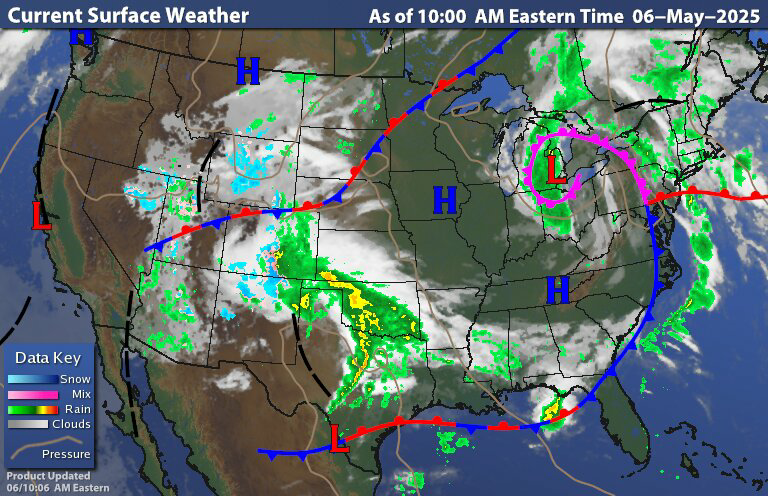

The surface chart shows the upper level low Has not moved all that much from where it was yesterday. With this we have a stationary front close to the coast and a occluded and warm fronts moving in ahead of the attached cold front.s
Today will feature cloudy skies and coolish conditions. As has been the case for what feels like forever We will have scattered rain showers and isolated thunderstorms Some of these thunderstorms could be strong to severe. The Storm Prediction Center has a Slight Risk for severe weather across a large part of eastern Pennsylvania into southwest New York State and to New Jersey. They have a Marginal Risk for severe weather around that extending across much of the central part and eastern half of New York State.

The biggest risk will be the chance for strong damaging wind gust hail and possibly some flooding will be an issue as well. The risk for tornadoes is extremely low but not zero.
As these bands move through we could see heavy rain at times. In between these rounds of rain We could see the sun try to peek out from time to time. As the upper level low continues to move through And weaken We can expect the scattered showers Chances for thunderstorms to continue into tomorrow morning.
Tomorrow The upper level low Will be moving over new England All right Rain showers will be ending west to east across the region, parts of New York State and northern into central new England could still be dealing with lingering rain showers. Tomorrow night into Thursday morning most of the region should be drying out but there still could be a few lingering showers up over northern Maine. Then on Thursday we're going to see another area of low pressure approach. It will become a bit breezy for Thursday and Friday. With all of this we will see isolated to scattered showers develop.Along with this we're going to see yet another upper level low develop and increase the possibly of widespread scattered showers and possibly a few thunderstorms. During this time we will probably see some dry times but showers will be capable of being heavy at times Those with the best chance of seeing more in the way of rain will be south and east of central New York State.
The rain Will continue into Friday then Friday night into Saturday the upper level low will start to exit the region with rain ending west to east across the region.
For Sunday high pressure will be approaching most of us seeing a dry day, but there still will be a chance for a few isolated rain showers. By Monday the high pressure will be overhead providing sun and dry conditions. Tuesday will start out dry but an approaching area of low pressure will bring rain showers, these will be moving west to east during the day. The rain showers will be hanging around for Wednesday.
Thank you.
ReplyDeleteYou're welcome
DeleteSaturday Central Vermont?
ReplyDeleteLeftover rain showers for Saturday morning but as we get into the afternoon we should see more clearing. Most of the afternoon and evening should be fine and it does look like Mother's Day is going to be dry.
Delete