
Today is going to be cool with less of the breeze and should be dry for the vast majority of us. If you're going outside You will need at least a light jacket As temperatures are running 15-20 ° F below average. Last night saw patchy frost for some of the northern areas There was also some snow in the highest elevations. Tonight is going to be another chilly one with a chance for patchy frost over parts of New York State and northern and central New England.
The last several weeks has seen the pattern over the United States be a bit blocky. The pattern has become stuck at times. And for the most part we've been on the bad side of this block pattern leading to plenty of rain and coolish temperatures.
Ahead of the system, we're going to see a warm front lift into the region allowing us to warm a bit for Wednesday. Then as the cold front comes through we are going to really cool down for Thursday and Friday, Saturday we'll see temperatures warm a little but it's still gonna be quite chilly. By Sunday and Monday we should start to warm up but it still looks to be slightly below average for this time of year.
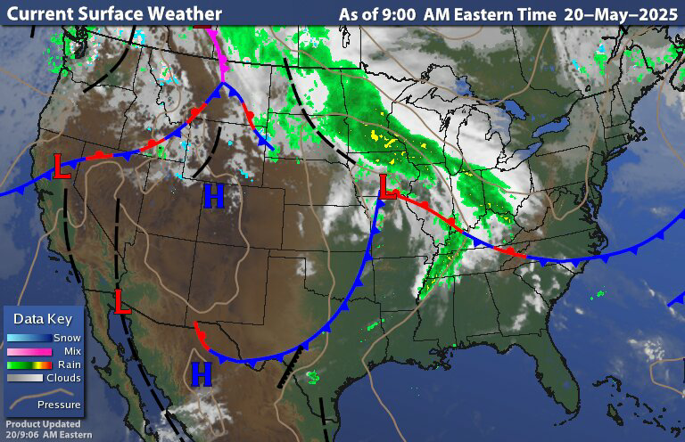

Image courtesy of tropical tidbits
When we look at the surface chart we have the departing system pulling east and another system approaching from the west. As I said yesterday, that upper level low system in the northern Plains is heading towards the Great Lakes and weakening. We're going to see another low develop to the south That will head north and east and then we're going to see an energy transfer from this low to one that's going to form near the Delmarvia Peninsula.

This system has brought a lot of severe weather to the Plains over the last couple of days Today the severe risk is sliding east a bit It's going to be centered around Kentucky Tennessee Alabama and Mississippi, These areas were already hit hard by severe weather and tornadoes A few days ago.

For Wednesday and Thursday The severe threat over the middle Atlantic and Northeast is very low. As we will be on the cool side of the system. But there is a slight chance for a few storms on the strong side in parts of southwest Pennsylvania.
The rain showers will reach southwest Pennsylvania this evening say 7- 8 PM. Then as we go through the overnight into Wednesday we will see the rain move north and east and become steady then widespread. The rain looks to reach central New York State during midday tomorrow. The rain then looks to reach eastern New York State late afternoon/ early evening, Western new England will likely see the rain begin later in the day/ evening. Rain will reach Eastern new England for places like Boston during the overnight into Thursday morning. and reaching Maine late Thursday into Friday.
The coastal low is going to become a late season Nor'easter. It will continue to develop as it heads towards the Cape on Thursday. And then into the Gulf of Maine on Friday.
Winds will become quite gusty with interior gust of 25-30 miles an hour and closer to the coast and along the coast to 40 to 45 miles an hour, with a chance for higher gust.
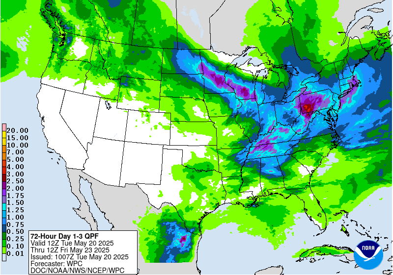
We're going to see quite a bit of rain out of this; interior parts of the region can expect half an inch to 2 inches, while those along and near the coastal plain will likely pick up 1-3 inches of rain. As the system develops rain will move west to east across the region; the rain will be heavy at times. So localized flooding will be an issue.
The weather will stay unsettled during the Memorial Day weekend. The system will be pulling away Saturday. But we will still be under the influence of the upper level feature, that will have rain wrapping around bringing scattered rain showers; that will become more isolated east to west. Then for Sunday most of us should stay dry but there will still be a chance for isolated rain showers. Memorial Day Monday looks to be mostly dry but there are still likely going to be a few isolated showers around the region. Sunday and especially Monday look to see temperatures warm to near to seasonal. So it won't be too bad for Memorial Day cook-outs. Looking ahead this general coolness looks to hang around for most of the rest of the month. But as we head towards and get into June I do expect to see more of a warm up more on a regular basis.
I'm not planning on posting tomorrow. As I will have personal business going on.
Thank you!
ReplyDeleteYou're welcome!
ReplyDeleteLooks like a traditional Nor'Easter for us in New England
ReplyDeletePretty much
Delete