
Still still dealing with the unsettled weather with severe potential.
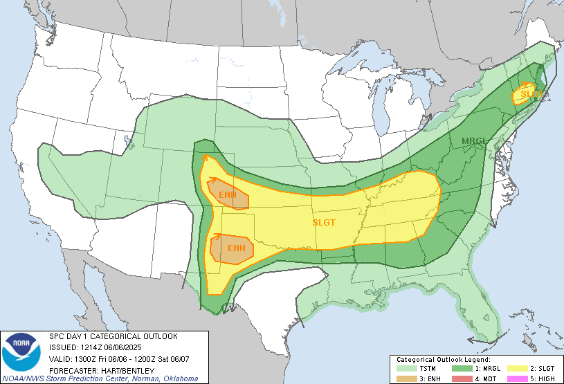
Today The storm prediction center (SPC) has central and southern new England, central to southeast New York State, much of Pennsylvania and western Maryland under a Marginal Risk for severe weather. They do have an area of Slight Risk for much of Massachusetts.
Today we're still dealing with the frontal boundary. As the nearly stationary cold front crawls across the region.
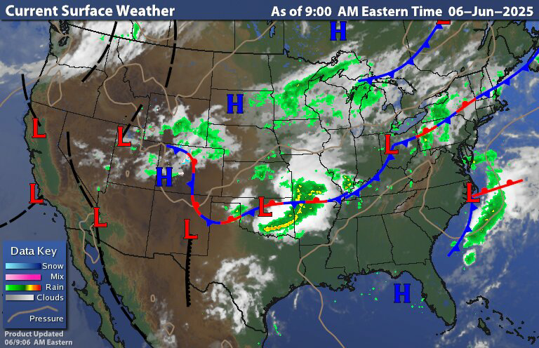

Looking at the surface chart and radar The cold front is basically stalled over Northwest Pennsylvania, New York state into central New England. The radar shows rain and thunderstorms near the frontal boundary. Those ahead of the front will have another hot humid day under hazy skies. As the front inches forward we will see scattered rain showers and thunderstorms. Some of these thunderstorms this afternoon and evening will be strong too severe. With the biggest danger being strong gusty winds, small to moderate size hail and some heavy downpours that could lead to some localized flooding. There is also a risk for frequent vivid lightning; so those who get under some of these thunderstorms could see a decent light show.
Tonight and tomorrow the front will move over southern Pennsylvania, Maryland and Delaware and then later Saturday into Sunday morning the front will stall out just to our south and off the coast.
Tomorrow much of the region will be at risk for garden variety thunderstorms. But the SPC Does have a Marginal Risk for severe weather for southeast Pennsylvania, Southern New Jersey and points south. The main threat will be strong damaging winds and some hail. Rain could be heavy at times.

The front will push the heat and humidity out of the region. But across Pennsylvania and the Middle Atlantic region the reprieve will be a short one, Later Sunday Into Sunday night The front will start to lift back north as a warm front bringing scattered rain showers and isolated thunderstorms back for southern Pennsylvania, Maryland Delaware, and southern New Jersey. across New York State and New England, Saturday afternoon through Sunday should be dry to mostly dry, with seasonal temperatures and humidity levels. Sunday night into Monday Clouds will be increasing south to north.There Will be a slight chance for some showers Far north of central New York State Into southern New England late Sunday evening/night. Then late Sunday night into Monday as the area low pressure gets closer the warm front will continue to lift north and east across the region, with the greatest risk for scattered showers and thunderstorms being closer to the front of boundaries as it lists north, areas south of the boundary could have a fairly dry Monday with only a chance for some isolated showers. Some of the storms on Monday could be strong too severe. But right now the severe threat looks rather limited. Monday night into Tuesday morning a cold front will be approaching. The cold front is going to slice through later Tuesday morning through Tuesday night. Bringing the risk for widespread rain showers and scattered thunderstorms. Some of these thunderstorms could be strong to severe. High pressure will approach and move in for Wednesday most of the region should be fairly dry. The same as true for Thursday, but a disturbance will be passing to our north so those across northern New York State and northern New England could see some showers and maybe a few isolated thunderstorms. Then for Friday high pressure is back in control providing a dry day.
No comments:
Post a Comment
Thank you for taking the time to comment, I will answer as soon as I can.