
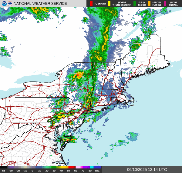
Likely tornado in western New York yesterday and stormy weather today.
The surface chart and radar show the heavy rain and enbedded thunderstorms are ahead of the cold front that sitting back over New York State Pennsylvania.

Satellite shows clearing over western parts of the region as the cold front continues to slide east towards New England. This clearing will continue today and into tonight.


For Wednesday, Thursday and Friday as the high pressure stays in charge; the region looks to be mainly dry with temperatures undergoing a warming trend. We will be dealing with that weak frontal boundary I talked about yesterday. Wednesday and Thursday will remain breezy. The boundary is going to divide the seasonal temperatures north of it from the slightly above average temperatures south of it. It will also be the focus of some isolated rain showers and thunderstorms for those near the boundary.
The boundary will be meandering over New York State and New England for Wednesday and Thursday, For Wednesday Most of the region should be dry, but there will be a chance for isolated rain showers. Thursday we'll see the chances for rain increase slightly Across the southern tear of New York State and the northern tier of Pennsylvania into parts of the Middle Atlantic as the front looks to stall Thursday over the southern tier and of New York State before undergoing more of a southern shift on Friday. Northern New York state and northern new England as well as Southern half of Pennsylvania into the middle of Atlantic Should be dry Wednesday and Thursday.

The front looks to continue sliding south on Saturday before stalling again, as another area of low pressure approaches. Rain showers could make it into western Pennsylvania And maybe western New York State during the day.
Sunday is going to see high pressure nosing in from the Atlantic. How strong the high pressure remains and how far west it extends will determine the scope and extent of rain coverage. So for now Sunday looks To feature rain showers over western parts of the region, with the eastern part of the region looking to be fairly dry. Rain could be heavy over western Pennsylvania and western New York State, along with thunderstorms. The low pressure will continue to push into the region on Monday bringing widespread rain showers and thunderstorms to the region. Rain could be very heavy at times. Tuesday is going to feature a few shortwave troughs moving through the region keeping things a bit unsettled.
No comments:
Post a Comment
Thank you for taking the time to comment, I will answer as soon as I can.