
It's Friday the 13th!
Here is the current surface chart and radar image.
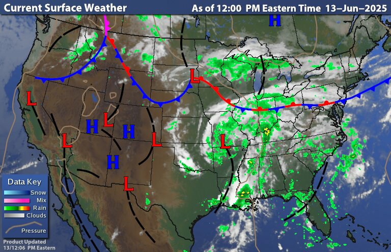

We can see the stationary front setting over the Mason Dixon line with isolated showers over most of the region. But we do have more In the way of widespread scattered showers over part of northern New York State extending into central New England. So today will feature low clouds, mostly scattered to isolated light rain showers and drizzle with temperatures that are slightly below average. I can't rule out a few heavier downpours and maybe a rogue thunderstorm over Pennsylvania, New Jersey, Maryland and Delaware But those will be more of an exception than anything.
Over the Father's Day weekend we will be dealing with a few waves of low pressure and shortwave troughs that will keep things unsettled, bringing isolated to scattered rain showers and maybe just a few thunderstorms. But the atmosphere set up doesn't really support these thunderstorms. But I'll just throw them in just in case. For the most part these showers will be light and won't hang around for a long time So if you have outdoor activities and cookouts planed, just keep an eye on the sky and have an umbrella handy just in case. For Saturday and Sunday The greatest chance for seeing rain will be from the New York Southern Tier and point south. Over the next few days winds will be quite breezy. So while it might not be great for the beach it won't be too bad I guess.
Monday will feature another area low pressure riding the frontal boundary just to our south. This will keep the weather unsettled with scattered to isolated rain showers and a chance for a few thunderstorms here and there. Tuesday will feature a trough moving through the region keeping things unsettled. Then Tuesday night and Wednesday another cold front come through bringing with it the chance for scattered showers and some thunderstorms. The cold front stalls for Thursday things will be unsettled with temperatures north and west of the boundary cooler than those south and east of the boundary. Next week temperatures are generally looking to be average too above average with humidity levels starting to creep up.
The tropics
It's been a little bit since I talked about the tropics. But to be fair there really hasn't been anything to talk about.
For those of y'all Who don't know, The Saharan Air Layer (SAL) is made of hot, dry and dusty air that comes off the Sahara desert and drifts west across the Atlantic basin. The SAL absorbs solar radiation making it hard for thunderstorms to develop. It also cuts off the moisture over the Atlantic and alters the atmospheric setup over the Atlantic, interfering with tropical cyclone development. We can see that in this SAL image.

Wind shear is also very high across the main development region of the Atlantic basin.


So while we will have to keep an eye on the western Caribbean into the Bay of Campeche. The conditions over the Atlantic basin should keep everything quiet for at least the next couple of weeks.
My next post will be on Monday. So I want to wish all the fathers and those doing the job and stepping up, a happy Father's Day!
I'm sure that the Atlantic will give you more than enough headaches over the next 5 months.Have a Wonderful Weekend.I have a BBQ being put on by our 3 children and 6 grandchildren.The Bourbon wings will start marinating tomorrow morning ( if I taught them right),maple chicken wings and steak.Send me some good weather,Thank You.
ReplyDeleteHave a Happy Father's Day Picnic
ReplyDeleteThank you
DeleteThank you and happy Father's day weekend.
ReplyDeleteSame to you
Delete