
A day closer to summer
Today is gonna be similar to what it was Yesterday. But we could see more in a way of scattered showers and isolated thunderstorms across the region and it will be slightly warmer and a bit more humid than it was on Monday. Here's a look at the current surface chart and radar.


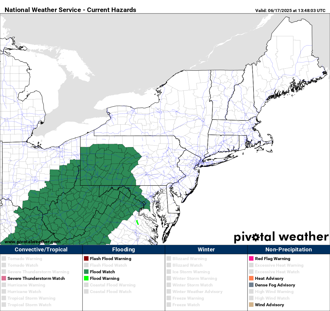
We can see we still have that stationary boundary to the south and we have some isolated to scattered showers over southern new England down into New Jersey , Delaware and Maryland. Other than that skies across the region will be overcast with drizzle and a few isolated showers, As I said above, the rain will be a little more widespread than it was yesterday.
Looking at the infrared satellite image.

We have a couple of systems that are going to be affecting our weather. The first is that system in the northern plains heading towards the Great Lakes, the second is over the eastern Plains and tracking east-northeast. As these get closer they will interact with that stalled out boundary forcing it to slowly lift north as a warm front. As this goes on we will start to see the cloud cover thin out with maybe a few breaks of sun south to north this afternoon. Temperatures and humidity will also be increasing as the frontal boundary moves north. As the front lifts north we will see scattered showers break out across southern Pennsylvania and Maryland along with a chance for isolated thunderstorms, some of these could be on the stronger side.

Yesterday I mentioned PWAT Values and how they will be high enough to cause some flooding issues across parts of the region.
For Wednesday as the warm front continues to lift north expect rain showers and isolated thunderstorms. Temperatures across the region are also going to be hotter with a noticeable increase in humidity levels. Again some of these storms will be strong too severe.

The hot and humid air is gonna continue to stream in the region on Thursday, then a cold front is going to slam into the hot and muggy air mass, setting off widespread rain showers and scattered thunderstorms. Some of these storms are going to be strong too severe.
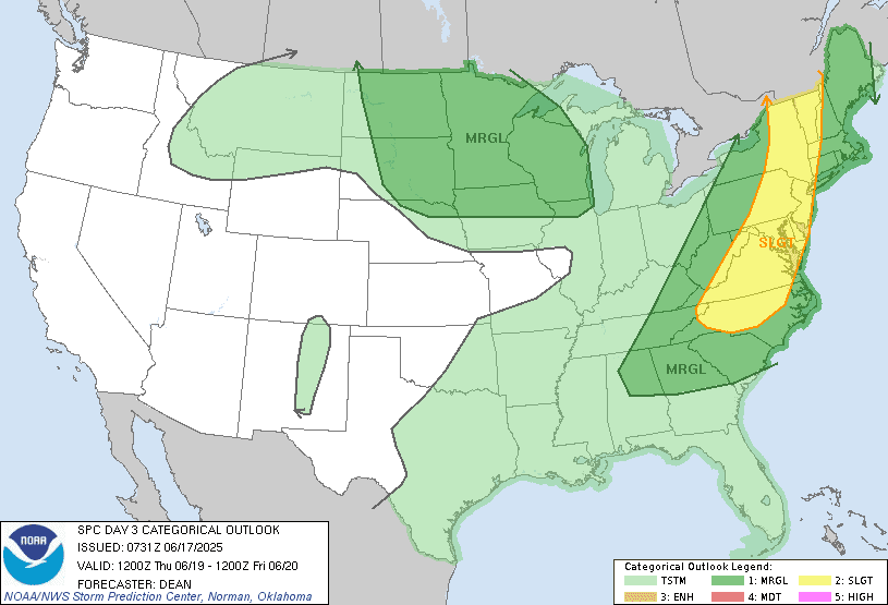
The storm prediction center does have a Slight Risk for severe weather across western New England, eastern/central New York State, eastern Pennsylvania, New Jersey, into Maryland and Delaware. Right now those with the best chance for seeing more in the way of widespread severe weather will be northern New York State, northern Vermont, New Hampshire into Maine. South of there the severe storms will be more isolated.
The greatest danger, will be strong damaging winds, hail, heavy downpours and frequent lightning. The tornado risk is low but not zero. The best time for severe storms will be from 2PM until 10PM.
Thursday night into Friday morning the cold front will be pushing east across New England, Exiting Maine by the afternoon. There will still be a chance for lingering showers From west to east with clearing from west to east. Does summer solstice will start Friday at 10:41 PM. Saturday will be cooler with less humidity, as high pressure approaches. But that low pressure area moving out of the great lakes into Canada could cause some isolated showers across new northern New York State. Sunday the high pressure will still be overhead with a trough well to our north that could kick off a few showers and maybe an isolated thunderstorm here and there. But The big story will be it getting noticeably hotter with more humidity moving in.
We're going to see the Bermuda high take over the pattern early next week; this will usher in a steep ridge with a southwest flow, allowing heat and high humidity into the North Atlantic region and Northeast.
By Monday Temperatures in the upper 80s and 90s will be prevalent across the region dew points are going to be in the 70s so it's going to feel very hot and humid ,with heat indexes in the 90s into a triple digits. Tuesday will be more of the same. Wednesday Should see the heat starting to loosen its grip But it's still gonna be quite warm. For some areas of the region this could be the first real heat wave of the season.
I hate Heat,Humidity but can get behind the Dark,Black Clouds the Strong Gusty Winds the Lightning Bolts and Thunder that rattles the windows.However right now the water is above ground level in many places and the rivers and streams are not roaring but it would not take much to bring them up quickly.
ReplyDeleteThanks for the info.
I agree on the amount of ground water in the watershed.
DeleteToo soon for the excessive heat and humidity. I’d rather have Fall. Spring does not seem to be a part of our climate anymore. But thank you. Guess we better get the a/c going.
ReplyDeleteYes early June is a bit early for this kind of heat But as I've been saying, I don't think this summer is going to see a lot of long duration heat waves. But we will see I guess.
Delete