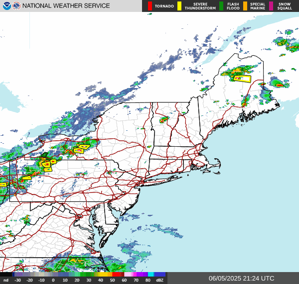
Here is a look at radar
Because of the increasing atmospheric instability and increased wind shear. The storm prediction center has increased today's severe threat to a Slight Risk across part of northern Pennsylvania into New York. The SPC has also expand the Marginal Risk over parts of the region.
Again today's severe threat will focus on the risk for damaging wind gust and small hail. But due to the high dew points heavy downpours from these thunderstorms will be possible. So there is the risk for some localized flooding. And as I said earlier there is the risk for frequent/vivid lightning inn some of these storms. So keep that in mind if you're gonna be outside.
The SPC has also increased tomorrow's severe risk to a Slight Risk.
Mesoscale Discussion 1127
We have a large collection of thunderstorms (Mesoscale Convective System) over the Ohio Valley. Atmosphere parameters The atmospheric parameters are such, that inside the core of the system we have a small area of low pressure that has developed. This is called a Mesoscale Convective Vortex. An MCV can increase the risk Damaging wind as the MCS tracks into southwest Pennsylvania. Because of the Increased risk for damaging wind gust, The SPC has released the discussion. The increased risk will last until around 8:00 PM. There is a chance that the SPC could issue a Severe Thunderstorm Watch.


Nothing but sun here in Adams and 22 miles to the South at the hospital my wife works at, the ambulances coming in said nice day if you like the heat and that was at 6:30 pm.It was freaky hot at 2:30,both of my weather stations had 97 one was 97.3 the other one had 97.7 by 4 one was at 89 the other at 90.
ReplyDeleteYeah it got fairly hot yesterday Pennsylvania and southern tier of New York got quite a bit of severe thunderstorms But the northern tier got little to none.
Delete