
It's Wednesday.
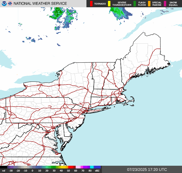
The surface chart shows a few areas of strong high pressure are dominating the Northeast and Middle Atlantic. Radar and satellite show nothing is going on overhead.We do have low pressure attached to a Stationary front over the Plains stretching into Canada.


Today the temperatures are slightly warmer than yesterday but humidity is still low providing a very nice day for all y'all, But there are clouds over eastern Pennsylvania down to Maryland , Delaware and New Jersey courtesy of the upper level ridge and a trough off shore. We do have a lot of storminess over the northern Plains. As the stationary front becomes a cold front and approaches from the west, all of this will be heading in our direction. Ahead of the front a strong southwest flow will pump heat and humidity into our region, starting tomorrow. Clouds will start increasing tomorrow afternoon. I can't rule out a few evening or Thursday night showers over far northern new England, But the vast majority of us should stay dry. That will change for Friday ahead of the cold front approaching. Heat and humidity will become oppressive. As the cold front moves into this tropical air mass showers and storms will break out Starting over northern and western New York State and northern New England morning into early afternoon These will drop south and east across the region during the day. Some of these storms will be strong to severe with the chance for damaging winds, some hail, very heavy downpours and frequent lightning. There will also be a risk for an isolated tornado or two. With the heavy rain the risk for localized flooding will once again be an issue. The rain will be ending over New York State and New England Friday evening and Friday night as everything slides to the south and east. The greatest time for severe weather will be 2PM through the evening. There is a good chance the SPC will upgrade part of the risk area to a Slight Risk.

Friday night and Saturday as the front slows and gets hung up there will still be a chance for rain showers and embedded thunderstorms for Pennsylvania, Maryland, Delaware and New Jersey. If low pressure develops along this frontal boundary rain could still be heavy at times. The frontal boundary will hang around for Sunday keeping the weather unsettled. The rain could stretch further north into New York State and New England. Again rain could be heavy at times this will be especially true across the Middle Atlantic I-95 corridor. For Monday the frontal boundary will finally push far enough south to clear the rain out of most of the region. But with a trough nearby I can't rule out a few rain showers here and there. Tuesday We will see another cold front approach. Ahead of the front we will see scattered rain showers and some thunderstorms. For Wednesday high pressure will build in bringing in mostly dry conditions, but there will still be the risk for a few isolated showers.
No comments:
Post a Comment
Thank you for taking the time to comment, I will answer as soon as I can.