
A quick post on today and the week ahead.

Today we're going to have that stationary boundary moving north. As the southeast ridge pushes some heat and heat and humidity into the region. Then we're going to have a cold front slice in bringing scattered showers and thunderstorms. Radar shows scattered Rain showers and some storms over northern New York State and northern New England
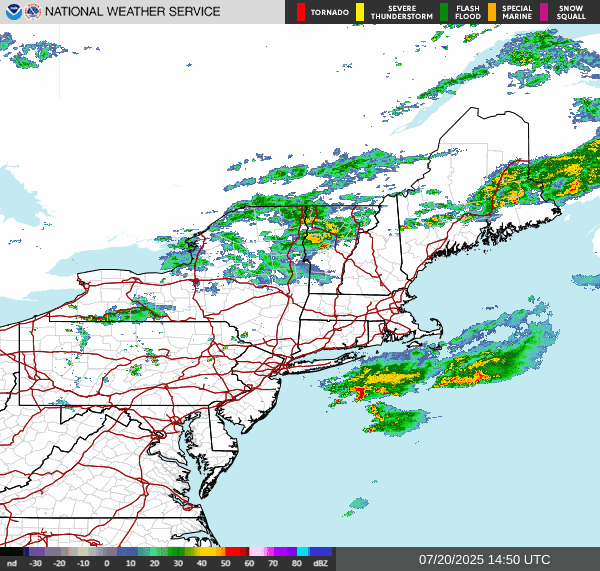
Some of these storms could be strong to severe with damaging winds, heavy downpours, hail and frequent lightning. The tornado risk is low but not zero. In the Friday post, I mentioned the risk for some severe storms on Sunday, right where the SPC has the risk area set up, so I did good.

The storm prediction center has a Slight Risk for severe storms across southern and central New England down to southeast New York State into northeast Pennsylvania and northern New Jersey. The greatest time for any severe storms will be this afternoon into the evening, 3-8 PM could get a bit wild. With the risk of heavy rain The weather prediction center does have a Marginal Risk for excessive rainfall and flooding inside the Slight Risk area.

Tonight high pressure is going to approach This will set up overhead for Monday into Thursday. The vast majority region will be dry For Monday through Thursday with only a very slight chance for a few showers here and there. Temperatures and humidity for Monday and to Thursday will be much more comfortable than they have been. Thursday ahead of an approaching frontal system we will see heat move in and humidity become oppressive. The cold front will slowly move through on Friday through Saturday. Bringing back the risk for scattered showers and thunderstorms. Some of these storms will be strong too severe. The upcoming weekend is going to be hot and humid. The cold front is going to stall over the region on Sunday, with the risk for scattered showers and thunderstorms continuing, especially near and along the stalled frontal boundary. South and east of the boundary the heat and humidity will remain.
No comments:
Post a Comment
Thank you for taking the time to comment, I will answer as soon as I can.