
The surface chart and radar


Shows the warm front lifting north with showers and thunderstorms moving with it. Warmer air and high humidity levels are moving along with the front. This will set the stage for some possible strong severe storms later this afternoon into this evening. The storms will be capable of strong damaging winds, some hail, Frequent lightning And locally heavy downpours. There is the chance for a couple tornadoes across the Northern Middle Atlantic Into southern New England. I do think the severe threat is going to be fairly isolated.
The storm prediction center Has a marginal risk for some severe weather over the northern middle Atlantic into southern New England, Along with a little 2% risk for very isolated tornadoes


The cold front well move through today into tomorrow morning, providing some showers and maybe thunderstorms. Then the front is going to slow and stall off the coast. This will keep the chance for some rain showers and possibly some isolated thunderstorms in the forecast for for Friday. Those with the best chance of seeing this We'll be closer to the coast. Some of the showers in the northern middle Atlantic into new England could be heavy at times. We're going to see high pressure move in for Saturday Providing A fairly nice day it should be mostly dry across the region. We're going to have a trough to our west near the Tennessee Valley and there will be an upper level low system that will develop. This will allow for rain and the Appalachians for Sunday. We're also going to have that tropical mess near Bermuda. All that tropical moisture Is going to try to push north Into the middle Atlantic as as well as the Appalachians. So these areas could see quite a bit of rain move in for Sunday into Monday. For the rest of our region The first part of next week will they be dependent happens in the tropics And how they end up tracking.
Tropical Atlantic

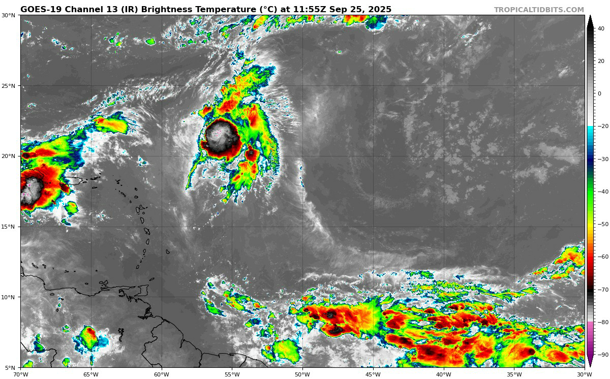

Gabrielle
According to the national hurricane center Gabrielle is a category 1 hurricane with max sustained winds of 75 mph and a minimum central pressure of 981MB. She is tracking east towards the Azores. The islands will see conditions deteriorate tonight. With the biggest impacts happening during overnight into tomorrow morning. Then her remnants will likely impact Portugal Monday into Tuesday of next week.

Image credit Tomer Burg
Humberto
93L was upgraded to Humberto yesterday afternoon.The
Currently the NHC, has Humberto with maximum sustained winds of 50 miles an hour, a minimum central pressure of 1004MB Tracking northwest at around 8 mph. Humberto Has been battling wind shear Bought that is starting to lessen And it should become light over the weekend. So, there is a chance Humberto reaches major hurricane status later Sunday or Monday.
This is still looking to stay east of the US East Coast. The forecast is dynamic So this could change. But for those in Bermuda and even Atlantic Canada will definitely have to keep an eye on this. currently it's looking to pass west of Bermuda But that is no sure thing.


Invest 94L
The NHC has 2 day development odds at 70% and 7day development odds at 90%. Currently it's winds are around 28 mph with a pressure of 1011 mb.
94L is currently tracking to the northwest over very warm sea surface temperatures (SSTs) and wind shear that is going to be dropping. So this has a chance to become Imelda over the weekend.


Image credit Tomer Burg
I-94L is going to very tricky, how she develops and where she goes, will be greatly dependent on Humberto, troughing approaching the East Coast, and building high pressure to it's east over the Atlantic.
I-94L will be moving into a favorable upper level environment. So there is a chance the southeast coast has a hurricane approaching during the first part of next week. We're also going to have high pressure building to the east of I-94L. There is a chance this could block 94L and give it a very good chance to head into the Southeast Coast.
We will have to see if this develops north or south of the Bahamas. If it develops south of the Bahamas there's a much better chance of it heading towards Florida and possibly the Gulf of America. And if it forms north of the Bahamas it will have a better chance of coming into Georgia and or the Carolinas and possibly come up into the Middle Atlantic and maybe closer to New England.
Right now it's unclear if 94L will come up the East Coast into the northern middle Atlantic And new England. or end up going out to sea before it reaches there. Even if 94L goes out to sea Tropical rainfall could still be an issue for parts of the northern Middle Atlantic into southern New England. The areas in Pennsylvania, Appalachians and northern Middle Atlantic that see rainfall on Sunday, could see a flooding situation develop.

so it must get complicated if the two hurricanes do a dance around their common center ( not the eyes)
ReplyDeleteYes the Fujiwhara effect and the other factors I mentioned, make for A complicated forecast and make I-94L very erratic.
Delete