
All our thoughts are with the families devastated by the terrible flooding that occurred in Texas.
Tropical storm Chantal formed on Saturday. Before she made her South Carolina landfall early Sunday morning strong wind shear disrupted the circulation and weakened her. The national hurricane center issued their last advisory on Chantal last night. She is now a remnant low.


Those around the Darmarvia Peninsula Well see occasional wind gust over 40 mph at times. As I said last Thursday she is going to bring heavy rain to the Mid Atlantic , Long Island and into parts of southern New England on her way out to sea, As she steers north and east due to the position of the northern jet stream and strengthening Bermuda high in the Atlantic. Both of these features are going to play a big role in our weather pattern over the next couple of weeks.
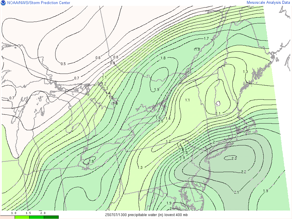
The precipitable water chart Show valleys around 2 inches. So expect some tropical downpours. Possibly leading to some flooding.
This week.
Yesterday we became quite hot and humid as the ridge built into the region. Today we're still going to be under that ridge making for another hot and humid day. The surface chart Shows a cold front dropping in out of Canada and the Great Lakes.

As the cold front slowly drops in we will see showers and thunderstorms develop around mid day into the evening. with the line, some of these could be strong to severe; this will be especially true over northern New England, parts of northern and western New York State back down into western Pennsylvania. Isolated storms could be capable of damaging winds some hail and heavy downpours. The slow moving nature of the storms could lead to some localized flooding issues. The best time for severe storms will be 2PM until around 9PM.

As the front continues to crawl south and east across the region,Monday night into Tuesday. The rain and thunderstorms will be advance with it. Here is a look at the storm prediction centers convective day 2 outlook. We can see the risk for severe weather is over southern new England back down through southeastern New York State and to eastern Pennsylvania and the northern Middle Atlantic. The main danger Is going to be strong damaging straight line winds, Heavy downpours and frequent lightning.

Wednesday we'll see the frontal boundary stall out South of the Mason Dixon Line over Virginia possibly just south of Maryland and Delaware. The boundary is gonna be hanging out generally over the same area for the rest of the week But it will be meandering back and forth a little bit. For Wednesday we will see scattered showers and thunderstorms likely south of the Mason Dixon Line. The SPC does have a Marginal Risk for severe weather over this area. But some of the rain and Thunderstorms could make it into parts of southern Pennsylvania. North of there the rest of the region should be dry for Wednesday.

For Thursday we're going to see a wave of energy move along the frontal boundary. This will bring worn away a widespread scattered showers and thunderstorms To the region on Thursday. The stationary boundary is going to continue to hang out For friday into Sunday Bringing the chance for showers and thunderstorms this will be especially true for those closest to the frontal boundary. It doesn't look like there will be any washouts for any day during this time. Sunday we will have a cold front approach and move through This will bring a greater chance for scattered showers and thunderstorms to the region for Sunday and Monday.
Looking ahead a bit
We're going to see the northern jet stream likely split. This will likely Keep our region fairly active. The strength and position of the Bermuda high Will be important as you go through the summer If it can come more west than it is currently we could get into more heat. But right now it looks like the region is going to see the same kind of weather pattern that we have been seeing. Temperatures swinging between cold and hot and quite a few chances for rain.
I hope everyone had a nice and safe independence day weekend. I want to give a personal opinion on the state of the country. I'm not going to get into the political side of everything that's going on. This isn't the place for that. But I do want to address one thing that I think we all can agree on. Being a citizen of the United States should be an honor and a privilege. No place on Earth has a way of life like we do. Every time I watch the news and many times in public I hear people saying what they can get from the country and they get upset when they don't think they're getting enough. But in my opinion being a citizen is a two-edged sword it's not only what the country can give to you but what you can give back not only to the country but to her citizens as well. We should truly treat each other as if they were our brothers and sisters This is especially true for those in need. We should be able to give freely of our time to help those who need it, not only money but we should give of ourselves as well. Kindness shouldn't be a commodity that we find too little of.
Don't know if you did it intentionally, but in your closing remarks you echo one of JFK's most famous lines from his inaugural speech: "And so, my fellow Americans: ask not what your country can do for you — ask what you can do for your country."
ReplyDeleteIt was strictly unintentional While I know of John Kennedy's speech and what you quote . My thought was more on how people should treat each other and just not live for government handouts.
DeleteExcellent
ReplyDeleteThank you
Delete